Real-time intelligence.
Operational awareness.
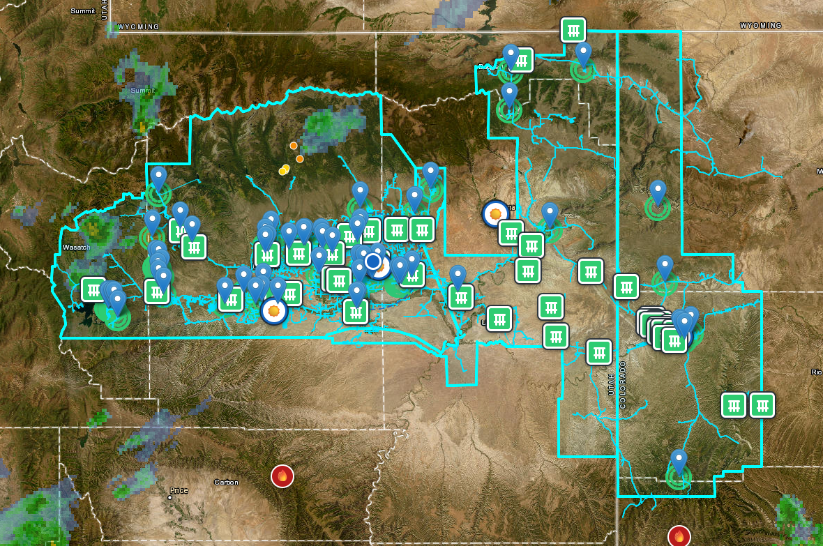
CoopIntel combines real-time weather observations, radar, lightning, wildfire, forecasts and electrical infrastructure into a single operational view — helping cooperatives understand what is happening across their system and what assets may be affected.
Better information for the people keeping the system running.
CoopIntel brings real-time weather and operational data together with service territory boundaries, power lines, substations, reclosers and other critical infrastructure so operators can quickly understand developing conditions across their system.
One view of the conditions developing across your territory.
Bring weather observations, radar, hazards and forecasts together instead of jumping between separate systems, websites and public weather maps.
Weather Stations
Monitor real-time weather observations throughout your service territory using available network stations or your own utility-owned stations.
Live Radar
View radar directly over your service territory and electrical infrastructure to see where storms are developing and what may be affected.
Fire Weather
Evaluate temperature, humidity, wind and other environmental conditions to identify elevated fire-weather risk and changing trends.
Wildfire
Display active wildfire incidents and perimeters in relation to the cooperative's service territory, facilities and electrical system.
Lightning
Track recent lightning activity near substations, power lines and other critical infrastructure.
Wind Analytics
Monitor sustained winds and gusts that may affect power lines, equipment, wildfire behavior and field operations.
Ice
Evaluate current and developing weather conditions for potential icing impacts to exposed electrical infrastructure.
Forecasts
View multi-day forecasts at selected locations throughout the cooperative's service territory.
Use the AWN network — or connect directly to your own stations.
CoopIntel can incorporate Ambient Weather Network data for hyperlocal weather visibility throughout a utility's service territory. Use available AWN stations in your area, connect directly to utility-owned Ambient Weather stations, or use both.
Take advantage of the existing AWN network
Available weather stations across and around your service territory can provide additional local observations without requiring a utility-owned sensor at every location.
CoopIntel can bring those observations into the same operational map used for radar, lightning, wildfire and utility GIS infrastructure.
Connect your own AWN weather stations
Utilities operating their own Ambient Weather stations can provide API access so those stations feed directly into CoopIntel.
Utility-owned stations can be strategically placed near substations, high-risk circuits, mountain areas, fire-prone locations and other parts of the system where hyperlocal weather intelligence is especially valuable.
See weather in the context of your electrical system.
The important question is not only where the weather is. It is what infrastructure may be affected.
More than a map you have to watch.
CoopIntel can continuously evaluate incoming weather, hazard and infrastructure information and surface developing operational concerns automatically.
Continuous Data Collection
Automatically collect new information from weather stations, radar, lightning, wildfire, forecasts and other configured sources.
Weather Station Analytics
Evaluate changes in temperature, humidity, sustained wind, wind gusts, rainfall and other observations instead of simply displaying raw values.
Infrastructure Evaluation
Evaluate hazards in relation to service territory, substations, lines, reclosers and configured monitoring areas.
Automated Notifications
Generate notifications when new weather conditions, hazards or operational concerns are detected.
Changing Condition Alerts
Surface meaningful changes as conditions become more significant instead of relying only on a single static threshold.
Duplicate Alert Protection
Prevent repeated notifications for the same event while continuing to monitor changing conditions.
Built around your territory, infrastructure and workflows.
Deployment-specific information can be managed through configuration and GIS files instead of being hard-coded into the application.
Territory & Infrastructure
- Service territory
- Power lines
- Substations
- Reclosers
- Other GIS assets
Weather & Monitoring
- Ambient Weather Network stations
- Utility-owned AWN stations
- Direct weather station API access
- Weather station search areas
- Forecast locations
- Monitoring distances
- Weather and hazard thresholds
Notifications & Access
- Email recipients
- SMS recipients
- URLs and endpoints
- Access settings
- Map behavior and layers
- Deployment-specific configuration
CoopForms
Digital safety and operational reporting for cooperatives.
CoopForms helps replace paper safety forms, scattered spreadsheets and manual reporting with a centralized digital system designed for utility and field operations.
Employees can complete forms from a phone, tablet or computer, capture electronic signatures, maintain searchable records and distribute completed reports to the people who need them.
CoopForms includes a public demo directly from the splash screen. Visit CoopForms.com and select View Demo — no company access code is required.
Safety Forms
Digitize tailboards, job briefings, inspections, safety documentation and other cooperative field workflows.
Mobile Field Access
Crews can complete forms from phones, tablets or computers while working in the field.
Electronic Signatures
Capture crew, employee, spotter and supervisor acknowledgements directly within the completed safety record.
Centralized Records
Keep completed reports organized and searchable instead of spread across paper files, email and separate spreadsheets.
Automated Report Delivery
Completed forms and reports can be distributed automatically to supervisors, safety personnel and other configured recipients.
Management Visibility
Supervisors can review submitted records and gain better visibility into safety reporting and field activity.
Controlled Access
Authentication and permissions help control who can submit, review and administer operational records.
Public Demo
Utilities can explore the platform directly from CoopForms.com's login screen by selecting the View Demo option.
Operational information stays protected.
Access controls can help protect both the user-facing platform and underlying operational information from unauthorized users.
Protected Access
Dashboard access can be protected using server-side authentication controls.
Persistent Sessions
Authorized users can remain signed in for a configurable period to simplify routine operational use.
Secure Data
Both the user-facing map and supporting data endpoints can be protected from unauthenticated access.
Better awareness.
Better decisions.
Purpose-built technology that helps cooperatives turn weather, GIS, operational data and field information into tools their employees can actually use.